


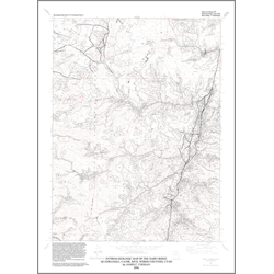
Interim geologic map of the Dairy Ridge quadrangle, leading margin of Willard thrust sheet, Cache, Rich, and Weber Counties, Utah (OFR-479)
By: J. C. Coogan
The Dairy Ridge and adjacent Horse Ridge quadrangles are located northeast of Ogden, Utah and southeast of Logan, Utah, in the southern Bear River (Monte Cristo) Range in Cache, Morgan, Rich, and Weber Counties, Utah. The range is the source of snow-melt runoff used in Utah and Idaho, and is largely unpopulated. Geologically the quadrangles are on the leading edge of the Willard thrust sheet, the western and older of several such sheets in the ?overthrust? belt of Utah, Idaho, and Wyoming. Strata on this leading edge of the thrust sheet are noticeably thinner and lithologically different than on the trailing edge of the thrust sheet, as exposed near Ogden and on the west side of the Bear River Range near Logan. Specifically, Proterozoic strata lack the key marker beds present in the Huntsville area, making correlations suspect. In the Dairy Ridge quadrangle, the leading edge of the Willard thrust sheet is marked by Proterozoic and Cambrian Geertsen Canyon Quartzite juxtaposed against Permian and Pennsylvanian strata of a thrust sliver and Triassic strata. In the Horse Ridge quadrangle, the Willard thrust fault is concealed by the Tertiary Wasatch Formation. Proterozoic to Mississippian strata of the Willard thrust sheet are exposed west of the topographic divide that is also the Weber-Morgan County line, while complexly folded and thrust-faulted Triassic and Jurassic strata are exposed east of the divide in Morgan County. After much discussion, the concealed trace of the Willard thrust is shown on the Horse Ridge geologic map west of the previously unrecognized Devonian and Mississippian strata in Howard Hollow, Morgan County. The Willard thrust was placed to the west because these strata are not overturned like the thrust sliver in the Dairy Ridge quadrangle, despite apparent thicknesses that are atypical for these strata.
Other Information:
Published: 2006
Pages: 19 p.
Plates: 1 pl.
Scale: 1:24,000
Location: Cache County, Rich County, and Weber County
Media Type: Paper Map