-
Salt Lake City, Utah - 30x60 Minute BLM Surface Management MapVendor: BLMUsing a 1:100,000 scale topographic map as a base, this Surface Management Status Map is color-coded in order to create distinctions between land managed by different agencies. The map shows the public lands designed as BLM, National Park Service, Forest Service, Trust Lands, Reservation,...
- $12.95
- $12.95
- Unit price
- per
-
Kings Peak, Utah - 30x60 Minute BLM Surface Management MapVendor: BLMUsing a 1:100,000 scale topographic map as a base, this Surface Management Status Map is color-coded in order to create distinctions between land managed by different agencies. The map shows the public lands designed as BLM, National Park Service, Forest Service, Trust Lands, Reservation,...
- $12.95
- $12.95
- Unit price
- per
-
Reprint 30x60 (100k) USGS Topographic MapsCustom Printing on out-of-state 30 x 60 (1:100,000) maps from the US Geological Survey Two Options for Printing 24 lb Paper - Standard Paper 7 mil Polypropylene - Tearproof and waterproof paper. Add the name or names of the 30 x 60 maps as...
- from $12.95
- from $12.95
- Unit price
- per
-
Rush Valley, Utah - 30x60 Minute BLM Surface Management MapVendor: BLMUsing a 1:100,000 scale topographic map as a base, this Surface Management Status Map is color-coded in order to create distinctions between land managed by different agencies. The map shows the public lands designed as BLM, National Park Service, Forest Service, Trust Lands, Reservation,...
- $12.95
- $12.95
- Unit price
- per
-
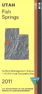
Fish Springs, Utah - 30x60 Minute BLM Surface Management MapVendor: BLMUsing a 1:100,000 scale topographic map as a base, this Surface Management Status Map is color-coded in order to create distinctions between land managed by different agencies. The map shows the public lands designed as BLM, National Park Service, Forest Service, Trust Lands, Reservation,...
- $12.95
- $12.95
- Unit price
- per
-
Duchesne, Utah - 30x60 Minute BLM Surface Management MapVendor: BLMUsing a 1:100,000 scale topographic map as a base, this Surface Management Status Map is color-coded in order to create distinctions between land managed by different agencies. The map shows the public lands designed as BLM, National Park Service, Forest Service, Trust Lands, Reservation,...
- $12.95
- $12.95
- Unit price
- per
-
Provo, Utah - 30x60 Minute BLM Surface Management MapVendor: BLMUsing a 1:100,000 scale topographic map as a base, this Surface Management Status Map is color-coded in order to create distinctions between land managed by different agencies. The map shows the public lands designed as BLM, National Park Service, Forest Service, Trust Lands, Reservation,...
- $12.95
- $12.95
- Unit price
- per
-
Hanksville, Utah - 30x60 MinuteBLM Surface Management MapVendor: BLMUsing a 1:100,000 scale topographic map as a base, this Surface Management Status Map is color-coded in order to create distinctions between land managed by different agencies. The map shows the public lands designed as BLM, National Park Service, Forest Service, Trust Lands, Reservation,...
- $12.95
- $12.95
- Unit price
- per
-
Tooele, Utah - 30x60 Minute BLM Surface Management MapVendor: BLMUsing a 1:100,000 scale topographic map as a base, this Surface Management Status Map is color-coded in order to create distinctions between land managed by different agencies. The map shows the public lands designed as BLM, National Park Service, Forest Service, Trust Lands, Reservation,...
- $12.95
- $12.95
- Unit price
- per
-
San Rafael Desert, Utah - 30x60 Minute BLM Surface Management MapVendor: BLMUsing a 1:100,000 scale topographic map as a base, this Surface Management Status Map is color-coded in order to create distinctions between land managed by different agencies. The map shows the public lands designed as BLM, National Park Service, Forest Service, Trust Lands, Reservation,...
- $12.95
- $12.95
- Unit price
- per
-
Lynndyl, Utah - 30x60 Minute BLM Surface Management MapVendor: BLMUsing a 1:100,000 scale topographic map as a base, this Surface Management Status Map is color-coded in order to create distinctions between land managed by different agencies. The map shows the public lands designed as BLM, National Park Service, Forest Service, Trust Lands, Reservation,...
- $12.95
- $12.95
- Unit price
- per
-
Price, Utah - 30x60 Minute BLM Surface Management MapVendor: BLMUsing a 1:100,000 scale topographic map as a base, this Surface Management Status Map is color-coded in order to create distinctions between land managed by different agencies. The map shows the public lands designed as BLM, National Park Service, Forest Service, Trust Lands, Reservation,...
- $12.95
- $12.95
- Unit price
- per
-
Dutch John, Utah - 30x60 Minute BLM Surface Management MapVendor: BLMUsing a 1:100,000 scale topographic map as a base, this Surface Management Status Map is color-coded in order to create distinctions between land managed by different agencies. The map shows the public lands designed as BLM, National Park Service, Forest Service, Trust Lands, Reservation,...
- $12.95
- $12.95
- Unit price
- per
-
Westwater, Utah - 30x60 Minute BLM Surface Management MapVendor: BLMUsing a 1:100,000 scale topographic map as a base, this Surface Management Status Map is color-coded in order to create distinctions between land managed by different agencies. The map shows the public lands designed as BLM, National Park Service, Forest Service, Trust Lands, Reservation,...
- $12.95
- $12.95
- Unit price
- per
-
Ogden, Utah - 30x60 Minute BLM Surface Management MapVendor: BLMUsing a 1:100,000 scale topographic map as a base, this Surface Management Status Map is color-coded in order to create distinctions between land managed by different agencies. The map shows the public lands designed as BLM, National Park Service, Forest Service, Trust Lands, Reservation,...
- $12.95
- $12.95
- Unit price
- per
-
Blanding, Utah - 30x60 Minute BLM Surface Management MapVendor: BLMUsing a 1:100,000 scale topographic map as a base, this Surface Management Status Map is color-coded in order to create distinctions between land managed by different agencies. The map shows the public lands designed as BLM, National Park Service, Forest Service, Trust Lands, Reservation,...
- $12.95
- $12.95
- Unit price
- per
-
Grouse Creek, Utah - 30x60 Minute BLM Surface Management MapVendor: BLMUsing a 1:100,000 scale topographic map as a base, this Surface Management Status Map is color-coded in order to create distinctions between land managed by different agencies. The map shows the public lands designed as BLM, National Park Service, Forest Service, Trust Lands, Reservation,...
- $12.95
- $12.95
- Unit price
- per
-
Seep Ridge, Utah - 30x60 Minute BLM Surface Management MapVendor: BLMUsing a 1:100,000 scale topographic map as a base, this Surface Management Status Map is color-coded in order to create distinctions between land managed by different agencies. The map shows the public lands designed as BLM, National Park Service, Forest Service, Trust Lands, Reservation,...
- $12.95
- $12.95
- Unit price
- per
-
Tule Valley, Utah - 30x60 Minute BLM Surface Management MapVendor: BLMUsing a 1:100,000 scale topographic map as a base, this Surface Management Status Map is color-coded in order to create distinctions between land managed by different agencies. The map shows the public lands designed as BLM, National Park Service, Forest Service, Trust Lands, Reservation,...
- $12.95
- $12.95
- Unit price
- per
-
Moab, Utah - 30x60 Minute BLM Surface Management MapVendor: BLMUsing a 1:100,000 scale topographic map as a base, this Surface Management Status Map is color-coded in order to create distinctions between land managed by different agencies. The map shows the public lands designed as BLM, National Park Service, Forest Service, Trust Lands, Reservation,...
- $12.95
- $12.95
- Unit price
- per

Local: 801-537-3320 Toll Free: 888-UTAHMAP (882-4627)
Hours: Monday–Friday 9 a.m. to 5 p.m.
-
-
- Recreation Books
- Adventure and Survival Books
- Hiking Books
- Outdoor Activities
- Fishing Maps & Books
- Rock Art and Scenic Books
- Nature Guide
-
Rockhounding, Geology and Mining
- Rockhounding, Geology and Mining
- Dinosaur and Fossil Books
- Geology Books
- Mineral Books
- Identification Field Guides
- Rockhounding Books
- Prospecting Books
- Mining Books
-
Navigation, First Aid and Knots
- Navigation, First Aid and Knots
- Knots Books
- First Aid Books
- Navigation Books
- Astronomy and Weather Books
-
- Geologic Publications
-
Economic Geology
- Economic Geology
- Engineering
- Minerals and Mining
- Uranium and Vanadium
- Coal Resources
- Fossil Energy
-
Minerals and Mining
- Minerals and Mining
- Gold
- Rocks, Minerals, and Fossils
- Mining
- Geologic Hazards
- Geothermal
- Great Salt Lake and Antelope Island
- Quaternary Studies and General Geology
- Paleontology and Paleoecology
- Stratigraphic Studies
- Water
- Public Interests
- Utah Geological Association
-
- Featured Maps and Books
- Exploring Southern Utah
- Utah Geological Survey - Survey Notes
Sidebar
Categories
- Maps
- Recreation Books
- Geologic Publications
- Discover More
- Featured Maps and Books
- Deals
Survey Notes


Recently Viewed Products
- Choosing a selection results in a full page refresh.