


Surface-water resources of the central Wasatch Front, Utah (M-54B)
M54B
In stock
Geologic Publications
$7.95
By: D. Price and L. J. Jensen
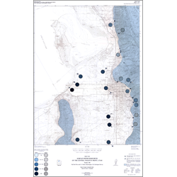
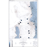
This map is one of a series that depict various aspects of the physical environment along the Wasatch Front between Tremonton and Logan on the north, and Santaquin on the south.
The purpose of this map is to show in a general way the amount and dissolved solids concentration of surface-water in the central Wasatch Front and to guide readers to sources of more detailed information about the resource.
Other Information:
Published: 1983
Plates: 2 pl.
Scale:1:100,000
Location: Davis County, Morgan County, Salt Lake County, Tooele County, Utah County, and Weber County
Media Type: Paper Publication