


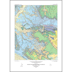
Geologic map of the Fisher Towers quadrangle, Grand County, Utah (M-183)
By: H. H. Doelling
The Fisher Towers quadrangle is located in the northeast part of the salt-anticline region of the Paradox basin in east-central Utah. Exposed bedrock ranges in age from Pennsylvanian to Jurassic; a small outcrop of a late Tertiary conglomerate is also present. In ascending order units include: the Pennsylvanian Paradox Formation, and Honaker Trail Formation; the Permian Cutler Formation; the Triassic Moenkopi Formation, and Chinle Formation; and the Jurassic Wingate Sandstone, Kayenta Formation, Navajo Sandstone; combined Dewey Bridge Member of the Carmel Formation, Slick Rock Member of the Entrada Sandstone, and Moab Member of the Curtis Formation; and Summerville and Morrison Formations (here undifferentiated). As much as 85 feet of the upper Tertiary Geyser Creek Fanglomerate fills a small paleocanyon in the east-central part of the quadrangle. Mapped surficial deposits are of alluvial, eolian, mass movement, and mixed eolian and alluvial origin.
Other Information:
Published: 2002
Pages: 22 p.
Plates: 2 pl.
Scale: 1:24,000
Location: Grand County
Media Type: Paper Map