


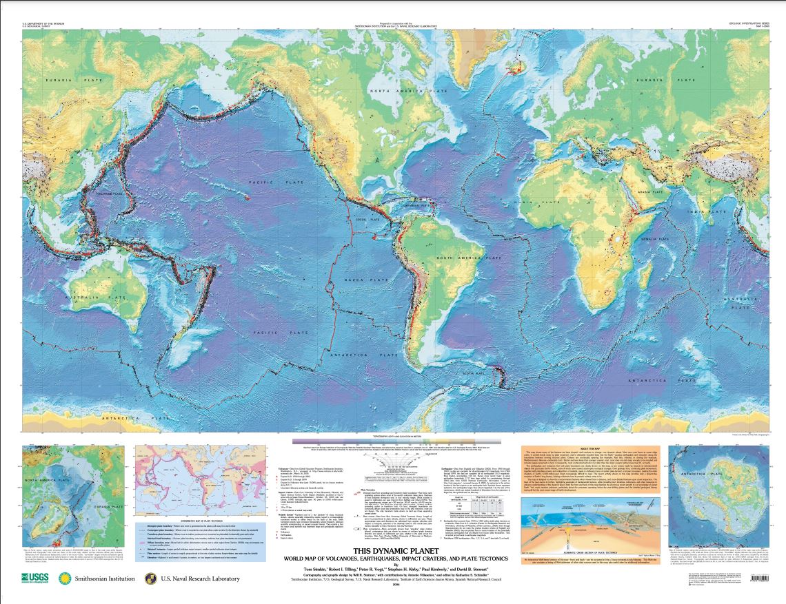


This Dynamic Planet: World Map of Volcanoes, Earthquakes, Impact Craters, and Plate Tectonics
This intriguing, double-sided tectonic map of the world is printed in striking colors.
"Our Earth is a dynamic planet, as clearly illustrated on the main map by its topography, over 1,500 volcanoes, 44,000 earthquakes, and 170 impact craters. These features largely reflect the movements of Earth’s major tectonic plates and many smaller plates or fragments of plates (including microplates). Volcanic eruptions and earthquakes are awe-inspiring displays of the powerful forces of nature and can be extraordinarily destructive. On average, about 60 of Earth's 550 historically active volcanoes are in eruption each year. In 2004 alone, over 160 earthquakes were magnitude 6.0 or above, some of which caused casualties and substantial damage.
This map shows many of the features that have shaped--and continue to change--our dynamic planet. Most new crust forms at ocean ridge crests, is carried slowly away by plate movement, and is ultimately recycled deep into the Earth--causing earthquakes and volcanism along the boundaries between moving tectonic plates. Oceans are continually opening (for example, Red Sea, Atlantic Ocean) or closing (for example, Mediterranean Sea). Because continental crust is thicker and less dense than thinner, younger oceanic crust, most does not sink deep enough to be recycled, and remains largely preserved on land. Consequently, most continental bedrock is far older than the oldest oceanic bedrock (see back of map).
The earthquakes and volcanoes that mark plate boundaries are clearly shown on this map, as are craters made by impacts of extraterrestrial objects that punctuate Earth's history, some causing catastrophic ecological changes. Over geologic time, continuing plate movements, together with relentless erosion and redeposition of material, mask or obliterate traces of earlier plate-tectonic or impact processes, making the older chapters of Earth's 4,500-million-year history increasingly difficult to read. The recent activity shown on this map provides only a present-day snapshot of Earth's long history, helping to illustrate how its present surface came to be.
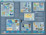
The map is designed to show the most prominent features when viewed from a distance, and more detailed features upon closer inspection. The back of the map zooms in further, highlighting examples of fundamental features, while providing text, timelines, references, and other resources to enhance understanding of this dynamic planet. Both the front and back of this map illustrate the enormous recent growth in our knowledge of planet Earth. Yet, much remains unknown, particularly about the processes operating below the ever-shifting plates and the detailed geological history during all but the most recent stage of Earth's development."
Other Information:
Dimensions: 59" x 42"
Location: World
Type: Paper Map
Source: USGS