


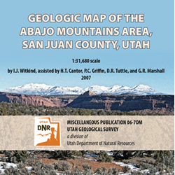
Geologic map of the Abajo Mountains area, San Juan County, Utah (MP 06-7dm)
By: I. J. Witkind, H. T. Cantor, P. C. Griffin, D. R. Tuttle, and G. R. Marshall
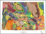
This digital data set represents the geology of the Abajo Peak, Mount Linnaeus, Shay Mountain, and Monticello Lake 7.5 minute quadrangles in the Abajo Mountains area of southeast Utah. The source for this data set was Plate 1 of U.S. Geological Survey Professional Paper 453, Geologic Map of the Abajo Mountains Area, San Juan County, Utah, by I.J. Witkind, assisted by H.T. Cantor, P.C. Griffin, D.R. Tuttle, and G.L. Marshall, published in 1964, at a scale of 1:31,680. Field mapping for this publication was completed in 1954-57.
This digital map is presented as a Portable Document Format and a ArcMap 9.1 project. These documents are the same as the published map except for minor changes.
The spatial data files are provided as ArcInfo coverages and ESRI shapefiles. In addition to the spatial data files, metadata, pdf, text, and image files are included to help the user view, evaluate, and utilize the spatial data.
Other Information:
Published: 1964 (digital 2007)
Plates: 2 pl.
Scale: 1:31,680
Location: San Juan County
Media Type: Paper Publication