


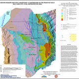
Ground-shaking map for a magnitude 7.0 earthquake on the Wasatch fault, Salt Lake City, Utah metropolitan area (PI-76)
By: I. G. Wong, W. J. Silva, D. Wright, S. S. Olig, F. X. Ashland, N. Gregor, and G. E. Christenson
This map illustrates the estimated intensity of ground shaking that would occur in a magnitude 7 earthquake on the Wasatch fault in Salt Lake Valley. The Salt Lake City metropolitan area is one of the most seismically hazardous urban areas in the interior of the western U.S., chiefly because of its location along the Wasatch front. The fault extends westward beneath the metropolitan area from its location near the eastern edge of the Salt Lake Valley (marked on the map by a heavy line). The Wasatch fault has generated large earthquakes (magnitude 7 and greater) repeatedly during the past few thousand years. The elapsed time since the last large earthquake on the “Salt Lake City segment†of the Wasatch fault is about 1,200 years and is approaching the average time interval between large earthquakes (about 1,400 years) based on the geologic record for the past 6,000 years.
Other Information:
Published: 2002
Plate: 1 pl.
Location: Salt Lake County
Media Type: Paper Map