


Geologic Map of the Southern Half of the Rill Creek and Northern Half of the Kane Springs 7.5′ Quadrangles, Grand and San Juan Counties, Utah (MP-175DM)
By: James P. Mauch and Joel L. Pederson.
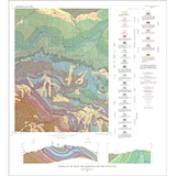
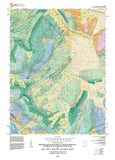
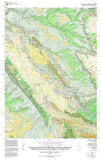
The adjoining southern half of the Rill Creek and northern half of the Kane Springs 7.5′ quadrangles are southeast of Moab, Utah. This area includes the southeastern half of the Moab-Spanish Valley salt graben and the neighboring bedrock plateaus to the southwest and northeast. Mapping of this quadrangle-sized area is part of a broader effort to understand active salt deformation and the associated landscape evolution and geologic hazards in the ancestral Paradox Basin. Strata from Late Triassic to Late Cretaceous age are exposed in the map area, and Quaternary-age units include alluvial, colluvial, eolian, mass-wasting, and fluvial terrace deposits. Graben subsidence is accommodated by systems of shallowly seated, near-vertical, gravitational faults along the margins of Spanish Valley. The two graben-margin fault zones display contrasting deformation styles and fault geometries. Ongoing Quaternary subsidence in Spanish Valley is documented in the spatial and temporal distribution of terrace deposits along Mill and Pack Creeks, which confirms previous hypotheses of active salt deformation. The hazard of active, aseismic, salt-dissolution collapse and faulting appears to be modest, with greater concern relating to attendant mass-wasting processes along the valley margins.
Other Information:
Published: 2023
Pages: 19
Plates: 2
Scale: 1:24,000
Location: Utah
Media Type: Paper Publication