


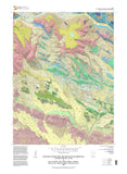
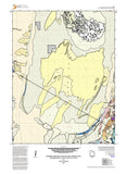


MOUNT POWELL 7.5 GEOLOGICAL MAP (MP16-5dm)
MP165
Unstocked
1:24,000 Geologic Maps
$14.95
The Mount Powell quadrangle straddles the crest of the Uinta Mountains in the High Uinta Wilderness Area. The quadrangle’s namesake, Mount Powell, is the seventh highest point in Utah at 4009 meters (13,153 feet). The geologic map includes the popular Red Castle area at the head of Smiths Fork Basin. The peaks and cliffs are comprised of the newly formalized formations of the Neoproterozoic (late Precambrian) Uinta Mountain Group, which is about 770 to 742 million years old. The basins, basin margins, and cirques are filled with glacial deposits of Smith Fork age—32,000 to 14,000 years ago (Pinedale equivalent). The quadrangle also straddles the anticline crest of the Uinta arch.