


Interim geologic map of the Saint John quadrangle, Tooele County, Utah (OFR-572)
OFR572
Unstocked
1:24,000 Geologic Maps
$13.95
By: S. M. Kirby
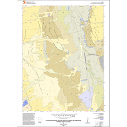
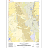
This Saint John quadrangle covers part of Rush Valley in southeastern Tooele County, Utah. The community of Saint John is along the Mormon Trail Road in the northwest part of the quadrangle. The grounds of the Tooele Army Depot south area cover part of the quadrangle along its eastern boundary. Information in this publication includes: map unit descriptions, a lithologic column, correlation of units, and a cross-section.
Other Information:
Published: 2010
Pages: 11 p.
Plates: 2 pl.
Scale: 1:24,000
Location: Tooele County
Media Type: Paper Map