


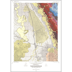
Geologic map of the Brigham City 7.5-minute quadrangle, Box Elder and Cache Counties, Utah (M-173)
By: T. R. Runnells and J. K. King
The Brigham City 7.5-minute quadrangle contains parts of the lower Bear River Valley and Wellsville Mountains. The mountain front is a part of the Wasatch Front, produced by displacement along the Wasatch fault zone. This fault zone is the most significant geologic feature in the quadrangle. The largest geologic feature in the Wellsville Mountains is a northeast-dipping homocline; it contains one of the more complete Cambrian sedimentary sections in northern Utah and a wellexposed record of Paleozoic continental shelf deposition. The mountains are broken by numerous faults and contain evidence for contraction during the Cretaceous to early Tertiary Sevier orogeny. A segmented major fault, transverse to the mountain front, divides the mountains into geologically different blocks. The mountain-front and subsurface data constrain the displacement during late Tertiary to present-day extension along the Brigham City segment of the Wasatch fault zone. Latest Pleistocene Lake Bonneville and two earlier Pleistocene lakes occupied the lower Bear River Valley. The Box Elder Canyon delta, a significant source of sand and gravel, formed in Lake Bonneville on the southeastern margin of the quadrangle. A deep borehole in the quadrangle provided additional data on Proterozoic rocks in northern Utah.
Other Information:
Published: 1999
Pages: 46 p.
Plates: 2 pl.
Scale: 1:24,000
Location: Box Elder County and Cache County
Media Type: Paper Map