


Maps of total Ferron coal, depth to the top, and vitrinite reflectance for the Ferron Sandstone Member of the Mancos Shale, central Utah (OFR-329)
By: D. E. Tabet, B. P. Hucka, and S. N. Sommer
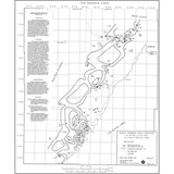
Three new maps were prepared of the Upper Cretaceous Ferron Sandstone Member of the Mancos Shale in central Utah to help understand its coalbed gas deposits. The maps show the total net coal thickness, the depth to the top of the Ferron, and vitrinite reflectance data for the Ferron coals. Data for these maps came from examining nearly 100 oil and gas, and several hundred coal exploration well records. The base for these new maps was taken from an earlier Utah Geological Survey (UGS) Open-File Report dealing with the hydrocarbon exploration potential of the Ferron Sandstone Member of the Mancos Shale in the Wasatch Plateau and Castle Valley of east central Utah.
Other Information:
Published: 1995
Plates: 3 pl.
Scale: 1:250,000
Location: Carbon and Emery Counties
Media Type: Paper Map