


Geologic map of the Fountain Green South quadrangle, Sanpete and Juab Counties, Utah (MP 95-1)
By: A. W. Fong
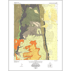
The Fountain Green South quadrangle is on the eastern part of the San Pitch Mountains in central Utah. The oldest exposed rocks are the marine Upper Jurassic Twist Gulch Formation. They are overlain by poorly exposed rocks of the Lower Cretaceous Cedar Mountain Formation. Pulses of the Cretaceous Sevier orogeny are represented by the piedmont slope and marginal deposits of the Indianola Group and the South Flat Formation. The Price River and North Hom Formations represent the waning stages of the Sevier orogeny and the onset of the early Tertiary Laramide orogeny. The westward-thinning Flagstaff Formation was deposited in nearshore facies of Paleocene-Eocene Lake Flagstaff, whereas the overlying Colton Formation indicates a change in environment from lacustrine to more fluviatile conditions. Quaternary units include tufas, alluvial fans, mass movements, stream alluvium, and pediment alluvium.
Structures mapped in the quadrangle include folds, normal faults, fractures, and a possible scissor fault. Most folds were caused by the Sevier and Laramide orogenies, while most faults formed during basin-and-range extension.
Other Information:
Published: 1995
Pages: 18 p.
Plates: 2 pl.
Scale: 1:24,000
Location: Juab and Sanpete Counties
Media Type: Paper Map