


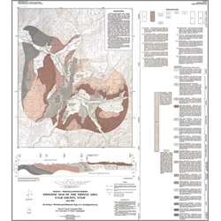
Geologic map of the Thistle area, Utah County, Utah (M-69)
By: I. J. Witkind and W. R. Page
During the second week in April, 1983 the Thistle earthflow began to move slowly downslope. Before long its toe had inched into the Spanish Fork Canyon disrupting both rail and highway traffic. By April 14 the earthflow had blocked the canyon.
The geologic map displays the geologic framework of the Thistle area before the earthflow began to move. In brief, the map indicates that a major eroded thrust plate composed of durable resistant formations, was at one time buried beneath a mantle of softer, chiefly unstable, formations. Subsequently, when these softer units were eroded, and the thrust partly exhumed, detritus from one of these softer units, the North Horn Formation, accumulated in narrow northeast-trending valley and formed the Thistle earthflow.
Other Information:
Published: 1983
Plates: 1 pl.
Scale: 1:24,000
Location: Utah County
Media Type: Paper Map