


Surficial geologic map of the Levan and Fayette segments of the Wasatch fault zone, Juab and Sanpete Counties, Utah (M-229)
By: M. D. Hylland and M. N. Machette
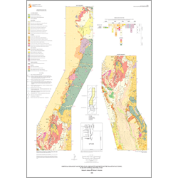
This map shows the surficial geology along the two southernmost segments of the Wasatch fault zone, the Levan and Fayette segments. Piedmont-slope fan alluvium of middle Pleistocene to late Holocene age dominates Quaternary deposits along the 44-km combined length of the segments. Other regionally important Quaternary deposits along the segments include unconsolidated to semiconsolidated fan alluvium and basin-fill deposits of Quaternary-Tertiary age, and fine-grained lacustrine deposits of late Pleistocene Lake Bonneville. Stream alluvium, landslide deposits, colluvium, and eolian deposits are also present locally.
This map combines new surficial geologic mapping with compiled existing geologic quadrangle mapping. Because documentation of late Quaternary faulting was not the primary purpose of the existing quadrangle maps, our new mapping focused on the relations between Quaternary deposits and fault scarps along the Levan and Fayette segments.
Other Information:
Published: 2007
Pages: 36 p.
Plates: 1 pl.
Scale: 1:50,000
Location: Juab County and Sanpete County
Media Type: Paper Map