


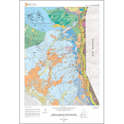
Surficial geologic map of part of the Kaysville quadrangle, Davis County, Utah (M-224)
By: B. J. Solomon
Sediments deposited by Pleistocene Lake Bonneville dominate the surficial geology of the Kaysville quadrangle. Lake Bonneville was a large ice-age lake that covered much of northwestern Utah between about 32,500 and 11,600 years ago. Several regional shorelines of Lake Bonneville are found in the Kaysville quadrangle. The earliest of these shorelines is the Stansbury shoreline, resulting from a climatically induced lake oscillation from about 24,400 to 23,200 years ago. A small part of the Stansbury shoreline is mapped on the east edge of Kaysville City, but this shoreline cannot be extensively traced because of subsequent erosion and deposition. The lake continued to rise until it reached its highest level about 18,000 years ago that was controlled by an external overflow threshold (the Zenda threshold) in southern Idaho, creating the Bonneville shoreline. The Bonneville shoreline forms a bench near the base of the Wasatch Range. About 16,800 years ago, catastrophic incision of the Zenda threshold lowered the threshold and lake level 340 feet in less than one year. Lake Bonneville stabilized at a lower level controlled by the Red Rock Pass threshold and formed the Provo shoreline, measured at an altitude of 4,810 feet by Currey where it crosses Hillfield Road in the northern part of the quadrangle. The lake oscillated at or near the Provo level until about 13,500 years ago, when climatic factors induced further lowering of the lake level, which eventually fell below the elevation of the present Great Salt Lake. Lake Bonneville subsequently rose and formed the Gilbert shoreline, mapped in the southwest part of the Kaysville quadrangle, from about 12,800 to 11,600 years ago. Lake Bonneville finally regressed about 10,000 years ago, leaving Great Salt Lake as one of its remnants. A lake rise about 3400 years ago resulted in the highest static lake level reached during the Holocene. Small parts of a shoreline formed at this level, commonly referred to as the Holocene highstand, are found near the current shore of Great Salt Lake.
This geologic map provides basic geologic information necessary to further evaluate geologic hazards and resources in the area, and to gain an understanding of the geology upon which this landscape developed.
Other Information:
Published: 2007
Plates: 2 pl.
Scale: 1:24,000
Location: Davis County
Media Type: Paper Map