


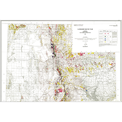
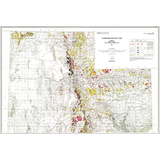
Landslide map of Utah (M-133)
By: K. M. Harty
Landslides are the most commonly occurring geologic hazards in Utah and have caused damage in both rural and urban areas of the state. Nearly 10,000 previously mapped landslides have been compiled onto the 1:500,000-scale base map of Utah. The map differentiates: 1.) shallow and deep-seated landslides and lateral-spread failures; 2.) surficial materials that include landslide deposits; 3.) historical and older landslides; and 4.) landslides compiled from generalized and detailed source maps. A computerized database containing information on landslide location and characteristics for approximately 2200 of the landslides on the map was developed during the compilation.
The distribution of different types of landslides can be associated with different geologic formations and physiographic regions in Utah. Geologic formations include the North Horn Formation, Farmington Canyon Complex, Ankareh Formation, Indianola Group, Manning Canyon shale, various Tertiary volcanic rock formations, the Tropic Shale, Mancos Shale, Chinle Formation, and Morrison Formation were identified as containing the most landslides. Landslides are most numerous in the Middle Rocky Mountains physiographic province, where high average annual precipitation and steep slopes contribute to slope instability.
Other Information:
Published: 1991
Pages: 28 p.
Plates: 2 pl.
Scale: 1:500,000
Location: Utah
Media Type: Paper Map