


Geologic map of the Mount Escalante quadrangle, Iron County, Utah (M-131)
By: M. A. Siders
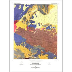
Tertiary volcanic rocks dominate the geology of the Mount Escalante quadrangle. Mainly Miocene in age, these rocks include regionally widespread ash-flow tuffs as well as local lava flows of rhyolitic to basaltic composition. Products of both calc-alkaline and bimodal (basalt plus rhyolite) volcanism occur within the quadrangle. The former includes the voluminous deposits of the Racer Canyon Tuff and underlying andesitic to dacitic flows, whereas the latter is best expressed by the Pinon Point rhyolitic complex and related basaltic lava flows. The topographic wall of a mid-Miocene caldera, inferred from field and geophysical data, is located in the extreme southwestern corner of the map area. The quadrangle lies within the Basin and Range physiographic province, just north of a diffuse transition zone separating it from the Colorado Plateau province to the southeast. The northern edge of the Delamar-Iron Springs mineral belt, which is coincident in part with the Timpahute lineament, passes through the southern part of the map area. Although the quadrangle does not have a history of mining, and no prospect pits or other workings were found during the course of mapping, some potential may exist for economic mineral deposits.
Previous published work encompassing the quadrangle includes the 1:250,000 and 1:500,000 compilation maps of Utah state geology by Hintze. The source of some regionally extensive Miocene ash-flow tuffs in southwestern Utah is the Caliente caldera complex west of the quadrangle.
Other Information:
Published: 1991
Pages: 9 p.
Plates: 2 pl.
Scale: 1:24,000
Location: Iron County
Media Type: Paper Map