


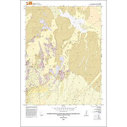
Interim geologic map of the Vernon NE Quadrangle, Tooele County, Utah (OFR-562)
By: S.M. Kirby
The Vernon NE quadrangle covers part of the southeastern floor of Rush Valley, in southeastern Tooele County, Utah, in the eastern Basin and Range Province. The Pony Express Road extends from east to west across the quadrangle and the Union Pacific Railroad crosses the southwest quarter of the quadrangle. Sabie and Boulter Creeks flow northeast across the southeast quarter of the quadrangle. The quadrangle consists of low hills, alluvial surfaces, and channels that slope gently towards a low-lying playa surface near the northern quadrangle boundary.
This map labels and discusses the exposed deposits, unconsolidated deposits, and bedock deposits found in the quadrangle.
Other Information:
Published: 2010
Pages: 10 p.
Plates: 2 pl.
Scale: 1:24,000
Location: Tooele County
Media Type: Paper Map