


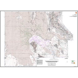
Interim geologic map of the Dugway Proving Ground and adjacent areas, parts of the Wildcat Mountain, Rush Valley, and Fish Springs 30'x60' quadrangles, Tooele County, Utah (year 2 of 2) (OFR-532)
By: D. L. Clark, C. G. Oviatt, and D. Page
This map covers the Dugway Proving Ground and adjacent areas. Information in this publication includes: geologic units descriptions, a correlation of geologic units, and five lithologic columns. This Open-File release makes information available to the public during the review and production period necessary for a formal UGS publication. This map may be incomplete, and inconsistencies, errors, and omissions have not been resolved. While the document is in the review process, it may not conform to UGS standards; therefore it may be premature for an individual or group to take actions based on its contents.
Other Information:
Published: 2008
Plates: 3 pl.
Scale: 1:75,000
Location: Tooele County
Media Type: Paper Map