


Coalbed methane resource map, Castlegate D bed, Book Cliffs coal field, Utah (OFR-176E)
By: A. C. Keith, J. S. Hand, and A. D Smith
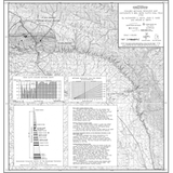
A general resource estimate map showing the location of drill core samples and the resultant methane contents in the Castlegate D bed. The samples were collected by the Utah Geological and Mineral Survey independently and as part of a cooperative agreement with the U.S. Department of Energy.
The generalized resource boundary is based upon a four-mile radius of influence. Local sampling experience in the Book Cliffs supports the use of this four-mile radius. With the addition of future methane information, this radius of influence should be recalculated. The designation of a favorable recovery area displays the interpretation of the coal bed methane graph. This area should yield the greatest methane recovery.
Other Information:
Published: 1990
Plates: 1 pl.
Scale: 1:100,000
Location: Carbon and Emery Counties
Media Type: Paper Map