


Geologic map of the Richmond quadrangle, Cache County, Utah (MP 95-3)
By: J. Brummer and J. McCalpin
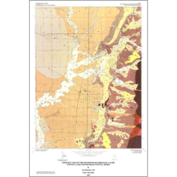
The Richmond 7.5-minute quadrangle contains portions of the Bear River Range and Cache Valley, and was affected by the Jurassic to early Tertiary Sevier orogeny, and late Tertiary basin-and-range normal faulting. Normal faulting continues and is a significant hazard in the area, as shown by the August 1962 earthquake. Many allochthonous blocks of lower Paleozoic and Precambrian rocks have been mapped that are apparently the product of middle Tertiary low-angle normal faulting and large-scale late Tertiary mass movements. Surface and sub-surface data show that latest Pleistocene Lake Bonneville and at least one earlier Pleistocene lake occupied Cache Valley. Research for this project produced the first documentation of zeolites in the subsurface in the late Tertiary Salt Lake Formation, and a summary of oil and gas exploration in the area. This research also refined the locations and ages of high-angle normal faulting along the Miocene to Holocene East Cache fault zone.
Other Information:
Published: 1995
Pages: 22 p.
Plates: 2 pl.
Scale: 1:24,000
Location: Cache County
Media Type: Paper Map