


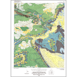
Geologic map of the Big Bend quadrangle, Grand County, Utah (M-171)
M171
In stock
1:24,000 Geologic Maps
$8.95
By: H. H. Doelling and M. L. Ross
The Big Bend quadrangle is named for a deeply incised meander bend in the Colorado River in southern Grand County, Utah. It is part of Utah's scenic Red-Rock country and includes the world-famous Delicate Arch and parts of Cache, Castle, and Professor Valleys. The quadrangle lies in the fold-and-fault belt of the northern Paradox basin, a northwest-trending asymmetrical basin that formed adjacent to the ancestral Uncompahgre uplift during Pennsylvanian to Late Triassic time.
Other Information:
Published: 1998
Pages: 29 p.
Plates: 2 pl.
Scale: 1:24,000
Location: Grand County
Media Type: Paper Map