


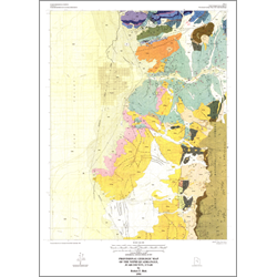
Provisional geologic map of the Nephi quadrangle, Juab County, Utah (M-137)
By: R. F. Biek
The Nephi quadrangle lies in central Utah in the transition zone between the Basin and Range, Middle Rocky Mountains, and Colorado Plateau physiographic provinces. Stratigraphic units range in age from Early Permian to early Holocene. They record: 1) relatively continuous Permian to Triassic sedimentation in the Cordilleran miogeocline, 2) development of the Jurassic Sevier orogenic belt in eastern Nevada and western Utah, 3) deposition of evaporite-bearing strata in a foreland basin east of this positive area, 4) Late Cretaceous Sevier orogenic activity resulting in eastward progradation of synorogenic sediments and emplacement of the Nebo allochthon, and 5) Cenozoic deposition of fluviatile volcaniclastics and normal faulting associated with basin and range extension.
Other Information:
Published: 1991
Pages: 21 p.
Plates: 2 pl.
Scale: 1:24,000
Location: Juab County
Media Type: Paper Map