


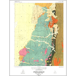
Provisional geologic map of the Levan quadrangle, Juab County, Utah (M-135)
By: W. L. Auby
The Levan quadrangle is located along the northwestern part of the Gunnison Plateau. Rocks mapped range from Jurassic marine sediments to Quaternary surficial deposits. The Jurassic Arapien Shale is the most extensive unit mapped and, despite its name, is composed largely of thin-bedded to laminated micrite. Terrestrial Cretaceous strata were deposited in a thick, coarse clastic wedge adjacent to the Sevier orogen. Latest Cretaceous and early Tertiary strata were deposited in a foreland basin between the Sevier orogenic belt and the Laramide uplifts farther east. Depositional settings at that time progressed from alluvial to lacustrine. Volcanism occurred in the Oligocene and Miocene and is represented by volcaniclastic sediments and igneous intrusives. Monzonite intrusives yield a radiometric age of approximately 23.4 Ma. The Pleistocene is represented by large mass-movement deposits.
Preliminary mapping, which included the Levan quadrangle, was first conducted by Hunt as part of his study of the northern Gunnison Plateau. The tectonic development of the plateau was first addressed by Spieker. The idea of salt tectonics as a mechanism for the tectonic development of the region was first hypothesized by Stokes, and more recently by Witkind. Gilliland recognized the possibility of shale diapirism in Sanpete Valley. Standlee and others proposed that eastward-directed overthrusting and later basin and range normal faulting are the main mechanisms of tectonic development in central Utah.
Other Information:
Published: 1991
Pages: 13 p.
Plates: 2 pl.
Scale: 1:24,000
Location: Juab County
Media Type: Paper Map