


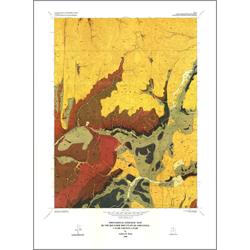

Provisional geologic map of the Boulder Mountain quadrangle, Cache County, Utah (M-125)
By: A. R. Mork
The Boulder Mountain 7.5-minute quadrangle is located in the Bear River Range of north-central Utah. The quadrangle is underlain by allochthonous strata ranging in age from the late Proterozoic to Early Ordovician, which are unconformably overlain by Cenozoic deposits. The late Proterozoic to early Paleozoic section is composed of seven formations with an aggregate thickness of at least 6100 feet. In ascending order, the stratigraphic sequence includes the late Proterozoic to early Middle Cambrian Geertsen Canyon Quartzite, the Middle Cambrian Langston Dolomite, Ute Formation, Blacksmith Dolomite, Bloomington Formation, the Upper Cambrian Nounan Dolomite, and the Upper Cambrian to Lower Ordovician St. Charles Formation.
Other Information:
Published: 1990
Pages: 9 p.
Plates: 2 pl.
Scale: 1:24,000
Location: Cache County
Media Type: Paper Map