


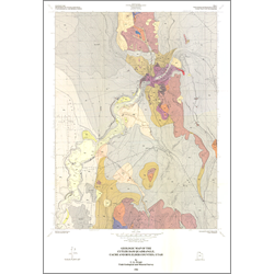
Geologic map of the Cutler Dam quadrangle, Box Elder and Cache Counties, Utah (M-91)
By: C. G. Oviatt
The Cutler Dam quadrangle comprises an area between the Wellsville Mountains, which constitute the northern end of the Wasatch Range, and Clarkston Mountain, which marks the southern end of the Malad Range. This area is near the eastern margin of the Basin and Range Province in the foreland of the Sevier orogenic belt. The quadrangle area includes the gorge of the Bear River, referred to as Cutler narrows, where the river passes through the southern part of the Junction Hills. Altitudes in the quadrangle range from about 4230 feet in the Bear River Valley to over 6100 feet in the Wellsville Mountains. The drainage divide between Cache Valley and the Bear River Valley traverses the eastern third of the quadrangle.
Other Information:
Published: 1986
Pages: 7 p.
Plates: 2 pl.
Scale: 1:24,000
Location: Box Elder County and Cache County
Media Type: Paper Map