


Geologic map of Salina quadrangle, Sevier County, Utah (M-83)
By: G. C. Willis
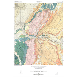
The Salina quadrangle contains about 23,000 feet of Middle Jurassic to Recent rocks, 16,000 feet of which are exposed to form four sequences. The oldest sequence consists of Middle Jurassic Arapien Shale and Twist Gulch Formation; the next has Late Cretaceous rocks, most of which were deposited in a foreland basin in front of the Sevier Orogenic belt. The two sequences are unconformably overlain by sub-horizontal fluvial and lacustrine units of the third sequence which comprises one of the most complete early Tertiary sections in Utah. The fourth group consists of Oligocene through Miocene reworked volcanic sediments and ash-flow tuffs. A wide variety of surficial deposits, including those of alluvial, colluvial, mass movement, and lacustrine origin, also occurs.
Other Information:
Published: 1986
Pages: 20 p.
Plates: 2 pl.
Scale: 1:24,000
Location: Sevier County
Media Type: Paper Map