


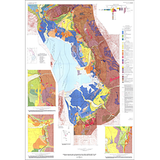
Surficial geologic map of the Wasatch fault zone, eastern part of Utah Valley, Utah County, and parts of Salt Lake and Juab Counties, Utah (I-2095)
I2095
In stock
1:62,500 and 1:50,000 Geologic Maps
$11.95
By: M. N. Machette
Geologic maps use a combination of colors, lines, and symbols to depict the relative age, composition, and relationships among rocks and sediments at and near the earth's surface.
Other Information:
Published: 1992
Plates: 1 pl.
Scale: 1:50,000
Color/B&W: Color
Location: Juab County, Salt Lake County, and Utah County