


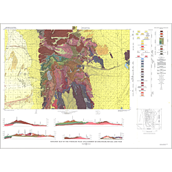

Geologic map of the Wheeler Peak and Garrison quadrangles, Nevada and Utah (I-578)
I578
Unstocked
Other Scale Geologic Maps
$10.00
By: D. H. Whitebread
Geologic maps use a combination of colors, lines, and symbols to depict the relative age, composition, and relationships among rocks and sediments at and near the earth's surface.
Other Information:
Published: 1969
Plates: 1 pl.
Scale: 1:48,000
Color/B&W: Color
Location: Millard County