


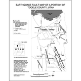
Earthquake fault map of a portion of Tooele County, Utah (PI-84)
PI84
Unstocked
Earthquakes and Seismology
$0.05
By: UGS Staff
This map shows the location of faults in Tooele Valley, between the Oquirrh Mountains and the Stansbury Mountains. Back side of map includes information on faults, effects of surface fault rupture, when and where surface rupture is likely to occur, and what can be done to protect homes.
Other Information:
Published: 2004
Pages: 2 p.
Location: Tooele County
Media Type: Paper Publication