


Sold Out

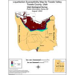
Liquefaction susceptibility map for Tooele Valley, Tooele County, Utah (PI-80)
PI80
Unstocked
Liquefaction Studies
$0.05
By: UGS Staff
The liquefaction-susceptibility categories of Tooele Valley are mapped based on local geology and subsurface soil and water conditions. In Tooele Valley, the most susceptible soils are along the shorelines of Great Salt Lake and Rush Lake. Answers are provided to questions about where liquefaction might occur, how liquefaction susceptibility is determined, and where to get additional information.
Other Information:
Published: 2003
Pages: 1 p.
Location: Tooele County
Media Type: Paper Publication