


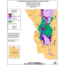
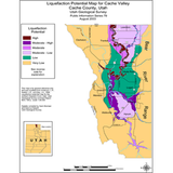
Liquefaction potential map for Cache Valley, Cache County, Utah (PI-79)
PI79
Unstocked
Liquefaction Studies
$0.05
By: UGS Staff
The liquefaction-potential categories of Cache Valley are mapped based on local geology and subsurface soil and water conditions and depend on the probability of having an earthquake within a 100-year period that will be strong enough to cause liquefaction in those zones. Answers are provided to questions about where liquefaction might occur, how liquefaction potential is determined, and where to get additional information.
Other Information:
Published: 2003
Pages: 1 p.
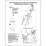
Location: Cache County
Media Type: Paper Publication