


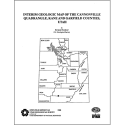
Geology of the Cannonville quadrangle, Kane and Garfield Counties, Utah (OFR-142)
By: R. Hereford
The Cannonville quadrangle is in Kane and Garfield Counties of south-central Utah. Cannonville is the principal community, although Tropic, on the northern boundary of the quadrangle, and Henrieville, 0.4 miles east of the quadrangle, contribute to the economic base of the area. The quadrangle is near the western edge of the Colorado Plateau physiographic province. This portion of the Colorado Plateau is in the Paria River drainage basin whose headwaters are north of the quadrangle in the Table Cliff Plateau and the Pink Cliffs of Bryce Canyon National Park.
Information in this publication includes: text of the geologic history of the quadrangle, a stratigraphic column, map unit descriptions, and a correlation chart of map units. This Open-File release makes information available to the public during the review and production period necessary for a formal UGS publication. This map may be incomplete, and inconsistencies, errors, and omissions have not been resolved. While the document is in the review process, it may not conform to UGS standards; therefore it may be premature for an individual or group to take actions based on its contents.
Other Information:
Published: 1988
Pages: 17 pl.
Plates: 1 pl.
Scale: 1:24,000
Location: Garfield County and Kane County
Media Type: Paper Map