


Quaternary geology of Fish Springs Flat, Juab County, Utah (SS-77)
By: C. G. Oviatt
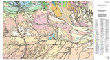
Fish Springs Flat is a sediment-filled valley between two tilted mountain blocks, the Thomas Range and the Fish Springs Range, in the Basin and Range physiographic province of western Utah. The valley is bordered on the north by the Great Salt Lake Desert and on the south by Whirlwind Valley. This report describes the surficial deposits of Quaternary age on the floor of Fish Springs Flat and along its peripheral piedmont slopes, an area of about 330 miles2, which was mapped at a scale of 1:50,000.
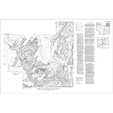
The purpose of this report is to describe the surficial deposits of Quaternary age on the floor of Fish Springs Flat and along its peripheral piedmont slopes. The map area is irregular and includes about 330 miles2, or the equivalent of about six 7.5-minute topographic quadrangles. Surficial deposits were mapped on 1:40,000-scale aerial photographs in the field during the months of June and July, 1988. The field data were later transferred to 1:24,000-scale orthophotoquads which were reduced to 1:50,000 and compiled to produce the map.
Other Information:
Published: 1991
Pages: 16 p.
Plates: 1 pl.
Scale: 1:50,000
Location: Juab County
Media Type: Paper Publication