


Geologic Map of the Willard Quadrangle, Box Elder County, Utah (M-278dm)
By: Adam P. McKean, Elizabeth A. Balgord, W. Adolph Yonkee, and Adam I. Hiscock
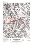
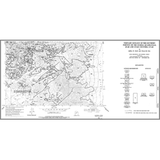
The Willard 7.5' quadrangle includes extreme topographic relief from Willard Bay and Reservoir to the high mountains and cliffs of the Wasatch Range. The Brigham City segment of the Wasatch fault zone divides the eastern mountains from the western valley floor, which contains deposits of Lake Bonneville, Gilbert-episode lake, and Great Salt Lake, and part of the Bear River delta. The bedrock is divided by the Willard thrust fault. The footwall includes metamorphic and igneous rocks of the Paleoproterozoic Farmington Canyon Complex and unconformably overlying Cambrian strata. The hanging wall includes metamorphic and igneous rocks of Paleoproterozoic to Mesoproterozoic Facer Formation and unconformably overlying Neoproterozoic metamorphosed strata of the Perry Canyon, Maple Canyon, Kelley Canyon, Papoose Creek, and Caddy Canyon Formations. A large landslide complex is near Facer Creek and a large rock avalanche is in Willard Canyon.
Other Information:
Published: 2018
Pages: 18
Plates: 2
Scale: 1:24,000
Location: Utah
Media Type: Paper