


Geologic map of the Washington Dome quadrangle, Washington County, Utah (M-209)
M209
In stock
1:24,000 Geologic Maps
$11.95
By: J. M. Hayden
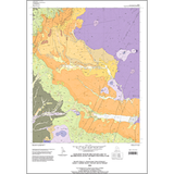
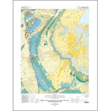
The Washington Dome quadrangle in southwest Utah is in the transition zone between the Basin and Range Province to the west and the Colorado Plateau to the east. The quadrangle straddles two structural blocks separated by the Washington normal fault, which trends north-northwest along the west part of the quadrangle. Washington Dome, part of the northeast-trending Virgin anticline, a Late Cretaceous, Sevier-age structure, is in the northwest corner of the quadrangle. Two reverse faults cut both flanks of the south end of the dome and may extend to the north end.
Other Information:
Published: 2005
Pages: 29 p.
Plates: 2 pl.
Scale: 1:24,000
Location: Washington County
Media Type: Paper Map